

Wind Chill Calculator
Calculate the wind chill "feels like" temperature from air temperature and wind speed.
Related calculators
About
Wind Chill Calculator
Wind chill is the temperature the air feels like on bare skin once moving air is stripping heat away from it. A 15 km/h wind at 10°C feels like 8°C, and exposed skin loses heat at about 714 watts per square metre under those conditions. The gap widens fast as it gets colder: at −20°F a 30 mph wind gives a wind chill of −53°F, and skin can freeze in about half an hour.
The number is a measure of how quickly you lose heat, not of how cold the air is. A thermometer sitting outside reads the same whether the air is still or blowing a gale.
What wind chill is
Wind chill is a measure of the rate at which exposed skin loses heat to moving air, expressed as the still-air temperature that would feel the same. It is the winter counterpart of the summer heat index, which does the same job for humidity; the Heat Index Calculator covers that side.
Skin loses heat by conduction, convection and radiation. Wind chill is almost entirely about the convection term. Your body warms a thin layer of air sitting against the skin, and that warmed layer then acts as insulation. Wind blows it away and replaces it with cold air, which then has to be warmed too. The faster the air moves, the faster that layer is stripped and the faster heat leaves.
The body responds by working harder to hold surface temperature, and if it cannot keep up, skin temperature falls. That drop is what you feel, and it is why a still −10°C day can be pleasant while a windy 0°C day is not.
The effect flattens out. Most of the cooling from wind arrives in the first 25 mph or so; beyond that the boundary layer is already gone and extra wind speed has progressively less left to remove. That is why the columns in the chart below bunch together at the bottom.
How wind chill is calculated
This calculator uses the wind chill temperature index adopted by the US National Weather Service and the Meteorological Service of Canada in November 2001, with T in Fahrenheit and V in miles per hour:
The same index has a metric form, with T in Celsius and V in kilometres per hour:
Both give the same answer to within a hundredth of a degree; the coefficients are simply rounded differently. Take the calculator's own default, 10°C with a 15 km/h wind. The metric form gives 7.914°C and the Fahrenheit form gives 7.927°C, and both are reported as 8°C.
The exponent of 0.16 is the part worth noticing. Wind speed enters at less than a fifth power, which is what makes the effect saturate: doubling the wind from 10 to 20 mph changes V0.16 by only about 12%.
The index is defined for air temperatures at or below 50°F and wind speeds at or above 3 mph. Below 3 mph there is no wind chill to report and the air temperature stands, which is why this calculator returns the plain temperature rather than the formula's output when the wind is light.
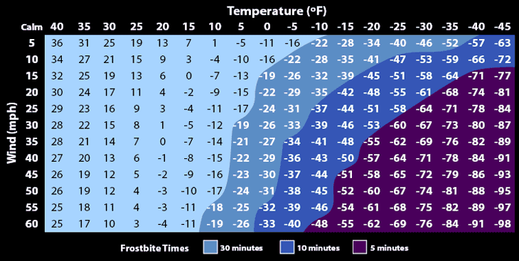
Read the chart by finding the wind speed on the left and the air temperature along the top. The shading marks how long exposed skin can be out before frostbite becomes likely, and the boundaries sweep to the left as the wind rises rather than running straight down the temperature columns, because a colder day needs less wind to reach the same rate of heat loss.
What changed in 2001
The wind chill numbers used before November 2001 were considerably harsher, and they were not measured on people. Paul Siple and Charles Passel derived the original index in Antarctica in 1945 by timing how long it took water in plastic cylinders to freeze under different winds. A cylinder of water is not a face, it sits well above ground where wind is faster, and it has no blood supply, so the resulting numbers overstated how cold a person would feel.
The replacement came out of human trials at Defence Research and Development Canada, where volunteers sat in a refrigerated wind tunnel with thermometers taped to their faces. The new model assumes a face 1.5 m above the ground rather than the 10 m height anemometers report, treats a walking pace of 3 mph as calm, and assumes clear night conditions with no sun.
The difference is large. At 20°F with a 20 mph wind, the old chart gave −10°F while the current index gives 4°F, a gap of fourteen degrees. At 0°F with a 25 mph wind the old figure was −44°F against −24°F today. If you are comparing a wind chill against something you remember from decades ago, the old one was almost certainly the colder number.
The heat loss figure this calculator also reports comes from that older Siple and Passel work, which is still useful because it expresses the result as a rate of energy loss in watts per square metre rather than as an equivalent temperature.
What wind chill does not tell you
Wind chill applies to bare human skin and to nothing else. This trips people up in three specific ways.
First, wind cannot cool anything below the air temperature. Wind chill describes how fast an object reaches air temperature, not how far it goes. Water pipes exposed to a −5°C wind will reach −5°C faster than in still air, but they will not reach the −20°C wind chill. If the air is above freezing, wind will not freeze your pipes, your car radiator or your plants.
Second, the index assumes uncovered skin. Clothing changes the answer completely, because the insulation you are wearing is doing the job the boundary layer was doing. A covered face in a 30 mph wind is not experiencing the charted wind chill.
Third, sunshine is not counted. Direct sun can make it feel roughly 6 to 10°F warmer than the index suggests, which is why a bright, breezy winter afternoon is more bearable than the number implies.
Wet skin is the case that runs the other way. Evaporation removes heat far faster than convection, so wind on damp skin or wet clothing is more dangerous than any wind chill figure indicates. Getting dry matters more than getting out of the wind.
Frostbite
Frostbite is the freezing of skin and the tissue underneath, and it starts at the extremities: fingers, toes, ears, nose and cheeks. Early signs are numbness, a change in skin colour and a cold, hard feel to the skin. Serious cases bring hypothermia and compartment syndrome, where swelling cuts off blood supply within a confined space.
How fast it happens depends on temperature, wind and how long the skin is exposed. At −15°F with a 30 mph wind, exposed skin can freeze in about 30 minutes. At −25°F with a 20 mph wind that falls to roughly 10 minutes, and in the darkest band of the chart above it is five minutes or less. The people most at risk are those out for long stretches: winter sports, outdoor trades, and anyone without shelter.
Frostbite is graded in degrees, in the same way burns are.
- First degree. Surface damage that usually is not permanent. Numbness and loss of sensation, sometimes with swelling. Skin may peel over the following weeks.
- Second degree. Blisters form and the skin surface hardens. The blistered skin dries, blackens and peels over the following weeks. Lasting cold sensitivity and numbness are possible.
- Third degree. Tissue below the skin freezes. Blisters and bluish discolouration appear, a blackened crust develops, and pain persists for weeks. Growth plates can be permanently damaged and ulceration can follow.
- Fourth degree. Tendon, bone and muscle are involved. The skin is hard and colourless and rewarming is painless, which is itself a bad sign. The tissue later blackens, and the full extent of the damage may not be clear for a month.
Prevention. Cover skin and scalp, avoid tight footwear and clothing that restricts circulation, and keep moving. Avoid being out in temperatures below −15°C without proper protection. Skip alcohol and drugs, which impair both circulation and judgement. Dress in layers, use warming devices, and learn to recognise frostnip, the early stage that numbs and whitens skin without ice forming in it. Frostnip is the warning; act on it.
Hypothermia
Hypothermia is a core body temperature below 95.0°F (35.0°C), reached when the body loses heat faster than it produces it. Symptoms run from shivering to cardiac arrest. Extreme cold is the usual cause, but alcohol, low blood sugar, anorexia and old age all make it more likely, and it can set in at temperatures well above freezing if someone is wet and exposed.
Mild. The body defends itself: shivering, raised heart and breathing rate, raised blood pressure. Urine production increases and mental confusion begins.
Moderate. Confusion deepens, along with amnesia, slurred speech, loss of fine motor control and slowed reflexes. Shivering may stop, which looks like improvement and is not.
Severe. Heart rate, breathing and blood pressure all fall. Two behaviours appear at this stage and both are recognised markers. Paradoxical undressing is the removal of clothing by someone disoriented by the cold, and it is recorded in a quarter to a half of hypothermia deaths. Terminal burrowing is the tendency to crawl into small enclosed spaces in the final stages.
Dressing for the cold
The right clothing depends on the range you are going into, and below a certain point the answer is to stay inside.
32 to 15°F (0 to −10°C). Dress warmly with the temperature in mind. No special precautions for short trips.
15 to −15°F (−10 to −25°C). Hypothermia is a real risk over long periods without adequate protection. Layer up: a thin wicking base layer to move perspiration off the skin, a thicker insulating layer of fleece, polyester or wool, and a wind-resistant outer shell, waterproof if there is any chance of wet. Hat, mittens and scarf.
−15 to −50°F (−25 to −45°C). Frostbite on exposed skin becomes likely and hypothermia is a serious risk. Same layering as above, with all skin covered, the face and hands in particular. Add insulation as needed, such as a synthetic or down jacket.
−50 to −75°F (−45 to −60°C). Exposed skin may freeze within minutes, with lasting damage. Heavier insulation, a wind and water-resistant outer layer, everything covered. Keep any time outdoors short, or cancel it.
−75°F (−60°C) and below. Conditions are hazardous. Exposed skin can freeze in under two minutes. Stay indoors.
Mittens beat gloves in serious cold, because fingers sharing one compartment keep each other warm. Cover the head: it is a small fraction of body area but it is usually the part left uncovered.
Using this calculator
Enter the wind speed in mph, km/h, m/s or knots and the air temperature in Fahrenheit, Celsius or Kelvin. The result gives the wind chill in the unit you chose, with the other two in brackets, alongside the equivalent heat loss for exposed skin and the frostbite time where one applies.
The chart highlights the cell nearest your inputs, so you can see where the conditions sit relative to the frostbite bands. If you are planning around forecasts rather than a single reading, note that reported wind speeds are usually averages: gusts will be well above the figure you type in, and the wind chill during a gust is correspondingly harsher. For the summer equivalent see the Heat Index Calculator, and for converting the wind speeds themselves the Speed Calculator handles all four units.
Common questions
Frequently asked questions
Wind chill is the temperature exposed skin feels when wind is carrying heat away from it, expressed as the still-air temperature that would produce the same rate of heat loss. At 10 degrees Celsius with a 15 km/h wind, the wind chill is 8 degrees Celsius. It measures the rate of cooling, not the actual air temperature.
With the 2001 National Weather Service index: wind chill = 35.74 + 0.6215T - 35.75V^0.16 + 0.4275 x T x V^0.16, where T is air temperature in Fahrenheit and V is wind speed in mph. A metric version with T in Celsius and V in km/h gives the same answer. The index applies at 50 degrees Fahrenheit and below, with winds of 3 mph or more.
No. Wind cannot cool anything below the actual air temperature; it only makes objects reach that temperature faster. If the air is at -5 degrees Celsius, pipes will cool to -5 and stop there, no matter what the wind chill reads. Wind chill applies to bare skin, which generates its own heat, and to nothing else.
The old index came from Siple and Passel measuring how fast water froze in plastic cylinders in Antarctica in 1945, which overstated human cooling. The 2001 replacement was built from trials on volunteers in a refrigerated wind tunnel. The difference is large: 20 degrees Fahrenheit with a 20 mph wind was -10 under the old chart and is 4 today.
It depends on both temperature and wind. At -15 degrees Fahrenheit with a 30 mph wind, exposed skin can freeze in about 30 minutes. At -25 degrees with a 20 mph wind that drops to roughly 10 minutes, and in the most severe conditions on the chart it is five minutes or less.
Hypothermia is defined as a core body temperature below 95.0 degrees Fahrenheit (35.0 degrees Celsius). It does not require extreme cold: being wet, windblown and inactive can bring it on at temperatures well above freezing. Alcohol, low blood sugar and old age all raise the risk.
Not to the covered parts. The index assumes bare skin, because it describes wind stripping away the thin layer of warm air the body maintains at its surface. Clothing does that insulating job instead, so a covered body is not experiencing the charted value. Any exposed skin, usually the face, still is.
Yes, and the index does not account for it. The formula assumes clear night conditions with no solar input, so direct sun can make it feel roughly 6 to 10 degrees Fahrenheit warmer than the number suggests. Wet skin runs the other way: evaporation removes heat much faster than wind alone, making damp conditions more dangerous than the figure implies.
Method
How this is worked out
The formula on this page follows:
Built and checked by Calculator Castle. Last reviewed . Spotted something wrong? Tell us and it gets fixed.